
Examples of some recent Salt Ecology projects are presented below. Please contact us if you would like more information.
Salt Marsh Restoration
Salt Ecology undertakes a full range of salt marsh restoration work including concept planning, site selection, design, planting and maintenance. Recent examples include:

Schematic layout of proposed restoration


Reinstatement of salt marsh habitat, Waikawa Estuary, Marlborough
Salt Ecology recently completed a salt marsh restoration project for Marlborough District Council (MDC) at Waikawa Estuary, Picton. The proposal, developed with Te Atiawa o Waka-a-Maui Iwi, the iwi which holds mana whenua and mana moana in Waikawa Bay, provided offset mitigation for flood control work being undertaken in Waikawa Stream. The project involved augmentation of cobble and gravel substrate to reshape the estuary shoreline, realignment and reinforcement of two small stream mouths to prevent flooding and maintain fish passage, and planting of 2625 rushes and coastal shrubs including intertidal beds of searush protected with small rock chenier sills.
Assessment of rehabilitation options
Salt Ecology were engaged by Tasman District Council (TDC) to provide advice about the relative priority, key considerations and potential issues associated with a proposed short-list of 16 estuary restoration projects within Waimea Inlet. The overarching objectives were to help identify: a diverse mix of ‘shovel ready’ projects easily undertaken using proven restoration methodologies, options to trial locally untested methods to determine their future efficacy and potential areas for future salt marsh expansion in response to SLR so they can be protected from inappropriate development.
Guidance on restoration techniques
In 2019, Environment Southland (ES) commissioned NIWA and Salt Ecology to report on “Remediation Options for Southland Estuaries” to identify the high-level benefits and feasibility of eight different estuary remediation options. The report included knowledge gaps, potential ecological side-effects, and the likelihood of success with respect to restoration targets. To extend this initial work and explore restoration options able to be more readily implemented at a community level, ES subsequently engaged Salt Ecology to provide additional advice on the active on-site restoration that could be undertaken for 1) Removal of nuisance macroalgae (seaweed); 2) Protection and restoration of salt marsh; 3) Protection and restoration of dunes.

Restoration design, Waimea Inlet, Nelson
Salt Ecology were engaged by Nelson City Council (NCC) to prepare restoration design options using nature-based solutions to mitigate shoreline erosion, prepare a planting schedule and to supervise site works to reinstate estuary salt marsh near Orchard Stream in the Waimea Inlet. Initial site preparation of the rock chenier was completed in May 2022, with planting scheduled to follow.
Macrophyte mapping and Water Quality assessments for coastal lakes and lagoons
Because coastal lakes and lagoons are often poorly flushed, they are highly sensitive to elevated sediment and nutrient inputs, as well as impacts from synthetic chemicals introduced through land runoff, industrial discharges and air pollution; introductions of non-indigenous plants and animals; and habitat losses through activities including drainage, reclamation and reduced flows (damming and irrigation). As many coastal lakes and lagoons are located in highly modified catchments, effective management requires timely knowledge of impacts from changes in catchment land use or intensification. Of particular concern are eutrophication (nutrient enrichment) impacts, and effects from fine-sediment input such as smothering of lake-bed habitat and increased water turbidity, which may in turn result in the loss of submerged macrophytes. Salt Ecology has designed and undertaken a variety of monitoring surveys to assess ecological condition, changes in state, and to guide management decisions.

Measuring macrophyte length

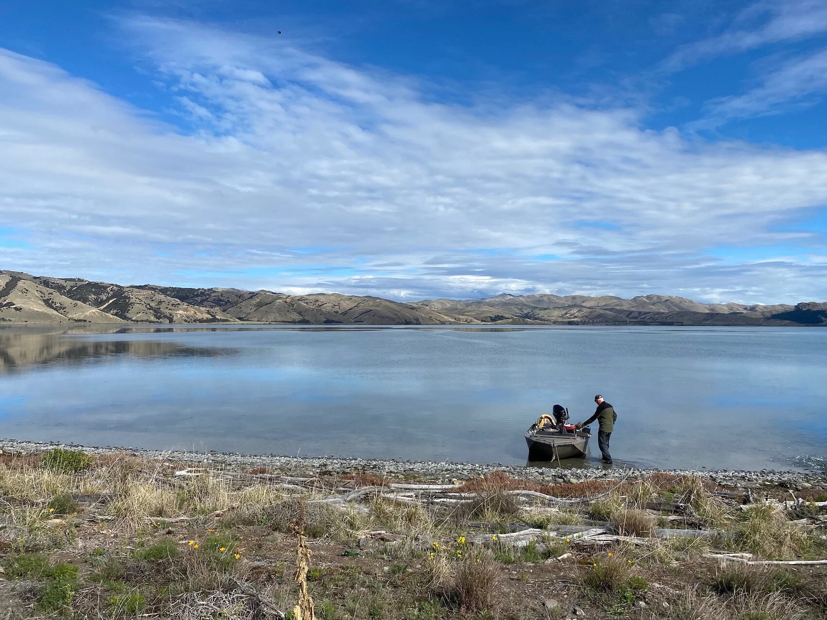
The Reservoir, Southland
The Reservoir is a small shallow coastal freshwater lake in eastern Southland and is one of several lakes Salt Ecology have assessed as part of Environment Southland’s long-term State of the Environment (SoE) monitoring programme. Submerged and emergent aquatic macrophytes were mapped, along with sediment and water quality samples. Results were analysed alongside Environment Southland's State of Environment water quality monitoring data to assess changes over time, and to understand the ecological health and potential drivers of lake degradation.
MARINE BIOSECURITY
Our science expertise and operational capability covers all aspects of marine biosecurity, including high-level technical advice, marine pest and vessel biofouling surveys, and stakeholder training and engagement. Examples of ongoing projects are:
Science advice and marine pest surveillance for the Top of the South Marine Biosecurity Partnership.
Biosecurity tools and decision support, including development and testing of a smartphone app for biofouling risk profiling of recreational vessels, and development of a web-based reporting interface for pest and vessel surveillance data (see: https://marinebiosecurity.gitlab.io/report/)
Analysis of benefits and costs for a Clean Hull Plan proposal for Top of the North Island regional councils.
Aquaculture biosecurity, including risk assessments, Biosecurity Management Plans for major offshore finfish aquaculture proposals, and advice on aquaculture of the Asian kelp Undaria pinnatifida.


Regional recreational vessel fouling and marine pest surveys
This report provides an example of reporting on summer surveys of biofouling and marine pests on recreational vessels, coastal structures and seabed locations conducted across the Top of the South (TOS) region from 2015/16 to 2018/19. The surveys involve checks of biofouling on boats by snorkel diving, using a level of fouling (LOF) scale that describes categories of fouling ranging from no macrofouling (LOF 1) to very heavy macrofouling (LOF 5). As well as LOF assessment, boats and associated structures and areas of seabed are simultaneously checked for the presence of six target marine pest species, in particular the Mediterranean fanworm Sabella spallanzanii. When boaters are present, they are given information on marine biosecurity and asked questions about their home port and vessel maintenance habits.
STATE OF THE ENVIRONMENT MONITORING
Salt Ecology provides State of the Environment monitoring and related services for regional councils nationwide. Many of our current projects underpin work supporting catchment limit setting approaches being developed for both freshwater and estuary management. Key areas include:
Broad scale habitat mapping of estuary substrate, salt marsh and seagrass following New Zealand’s National Estuary Monitoring Protocol, monitoring of estuary sedimentation (using sediment plates), and assessment of nuisance macroalgae (using the Opportunistic Macroalgal Blooming Tool - OMBT method).
Fine scale ecological monitoring of estuary sediments following New Zealand’s National Estuary Monitoring Protocol, assessing common sediment stressors e.g. heavy metals, nutrients, organic content and sediment macrofauna.
Rocky shore surveys. Recent projects have included ecological surveys at intertidal sites on Mana and Kāpiti Islands for Greater Wellington Regional Council, as well as providing support and guidance to Environment Southland in undertaking their regional rocky shore programme.
Soft sediment beach surveys. Recent projects have included ecological surveys at intertidal sites on the Kāpiti and Wellington Harbour coastlines for Greater Wellington Regional Council.
Our recent surveys have ranged from pristine estuaries in Stewart Island and the Catlins coast, to locations degraded by nutrients and muddy sediments as a result of catchment development. Some examples of recent SOE work are presented below.


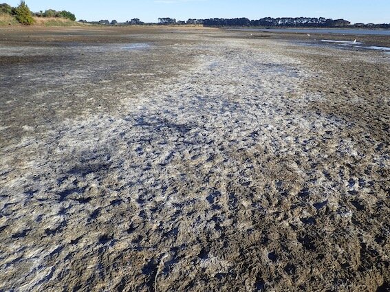
Broad-scale mapping of nuisance macroalgae
Many New Zealand estuaries with developed catchments are exhibiting nutrient enrichment problems evident through the proliferation of nuisance macroalgae. Where algal growth is excessive, impacts can occur through the smothering of intertidal habitats, with rotting algae causing low sediment oxygenation and conditions toxic to many animals. Salt Ecology undertakes regular monitoring of macroalgal biomass and extent in estuaries throughout New Zealand, with results used to set nutrient targets to reduce current problems and return estuaries to a healthier state.

This report describes the February 2021 survey of nuisance macroalgae in New River Estuary, Southland where significant and expanding growths of opportunistic nuisance macroalgae (seaweed) have been recorded during previous broad scale habitat mapping, coincident with increasing nutrient loads resulting in significant degradation of the estuary.

Measuring macroalgal biomass


Fine-scale monitoring of estuarine biota and sediment quality
New Zealand’s National Estuary Monitoring Protocol (NEMP) is intended to provide resource managers with a scientifically defensible, cost-effective and standardised approach for monitoring the ecological status of estuaries. The results establish a benchmark of estuarine health in order to better understand human influences, and against which future comparisons can be made. The NEMP includes fine scale monitoring of estuarine biota and sediment quality, with surveys typically conducted at intervals of 5 years after initially establishing a baseline.
Broad scale habitat mapping
Broad scale surveys involve describing and mapping estuaries according to dominant surface habitat features (substrate and vegetation). The type, presence and extent of substrate, salt marsh, macroalgae or seagrass reflects multiple factors, for example the combined influence of sediment deposition, nutrient availability, salinity, water quality, clarity and hydrology. As such, broad scale mapping provides time-integrated measures of prevailing environmental conditions that are generally less prone to small scale temporal variation associated with instantaneous water quality measures. Surveys are typically conducted at intervals of 5-10 years.

DATA VISUALISATION AND WEB REPORTING
A recent focus of our work has been developing web-based reporting tools that enable councils and the wider public to visualise and interact with monitoring data. Our ongoing work with Greater Wellington Regional Council and Nelson City Council reports across all environmental domains, including aquatic and terrestrial ecology, invasive pests, hydrology and rainfall, groundwater, and air quality. Click here for an example of a recent report for Greater Wellington, or for an online directory of GWRC reports: https://archive.gw.govt.nz/Annual-monitoring-reports/
Click below for an example of a story map output.

Research and Development
Good science doesn’t just happen. Underpinning our work is a robust programme of research and development. While much of it is undertaken in the background, it provides us with confidence that our work is reliable, repeatable and trustworthy. Key research areas include:
Evaluation of eutrophication responses in estuaries.
Development and refinement of the New Zealand Estuary Trophic Index.
Salt marsh restoration and nature based erosion protection.
Analyses of national data on spatial and temporal changes in the prevalence of intertidal seagrass.
Development of improved substrate classifications and methods for NEMP monitoring.
Development of GIS spatial mapping QA/QC tools that ensure standardisation of outputs.
Analysis of long-term data to understand key drivers of vessel hull fouling and marine pest prevalence on hulls.
Development of risk profiling app for vessels.